The Messenian Wars - Picture Map
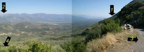
The Messenian War often interests students of ancient Greek history, historians and military enthusiasts. Visually understanding space, locations etc is difficult with words, it helps to be able to see with your own eyes. To help here, below are two of the same image taken on Mt Ithome, that shows the valley that seperates Sparta from the city of Messini.
Looking at the larger image, you will notice on Taygetos, the far off mountain range, houses and telephone towers looking like a tiny dot, this will help you understand the distances in the photos.
There are four numbers in the pictures indicating sites that are out of shot, these include:
1- The port city of Kyparissia is just out of shot because of the ridge.
2- The city of Sparta is on the other side of the mountain range, situated in the next valley.
3- The city of Messini, is out of shot to the right. Messini is as high up on Mt Ithome as the photographer of the picture is.
4-Over the left shoulder of the photographer, Mt Ithome towers even higher and is the highest mountain peak in the vicinity. An ancient walled off city (in ruin now) was at the top and used by Messenians when being invaded. So the reader can understand how steep it was, it was too steep for the photographer to drive up there. He began to try to walk to the very peak, but found it too steep! The locals say it can be done with a dirt motorbike.
With these pictures, we can only image the terror the Messenians felt watching a Spartan army march through the valley towards them.
|
Medium image
1500x544
|
|
|
Large image
4084x1480
|

